The system of record for storm restoration

Run every storm job from the first knock to the final check.

SkyCanvass is the operating system for storm-restoration roofing. Canvass the neighborhood, document the damage, build the supplement, and collect — without your jobs scattered across six tools and a truck full of photos.

Free to start · your first storm report is on us · no credit card.

SkyCanvassSearch jobs, customers, addresses⌘K
The SkyCanvass field-request panel — a crew member asks for a specific roof photo and it lands as a tracked task assigned to the build team, so nothing gets missed before the job closes out.
Built on authoritative public dataNOAA Storm EventsNWS Local Storm ReportsSPCMRMS MESHNEXRAD Level-IIUSGS 3DEP

The operating system

Five stages. One property record. Nothing falls through.

Canvass the verified storm, sign the inspection, document the build, attach source-backed evidence, and collect — every step writes to the same job.

01

Canvass

Map the verified storm, knock the affected doors, log every conversation in the field.

02

Lead

Turn an interested homeowner into a signed inspection with the agreement built in.

03

Job

Document the damage, schedule the build, and keep every photo and task on one record.

04

Supplement

Build the supplement with the storm report, code citation, and matching photo attached.

05

Cash

Invoice the final RCV, collect the balance, and reconcile — synced to your books.

Hail mapLive storm intelligence
Interactive hail map with MESH swath overlay, parcel outlines, and a drawn canvassing zone on a suburban neighborhood.

Storm intelligence

Draw the swath. Knock the doors the storm actually hit.

The interactive hail map layers NOAA MRMS MESH onto parcel boundaries — measured hail in inches, not a probability score. Draw your canvassing zone, export the door list, and route crews to properties inside the verified swath.

  • Timeline scrubber replays radar evolution minute by minute for the storm date you care about.
  • Parcel-level join ties every swath pixel to an address you can knock today.
  • Free to explore — property lookup and the hail map cost nothing; your first storm report is on us.

The cost of scattered work

Every storm you chase across six tools is money left on the roof.

The estimate is in one app, the photos on a phone, the agreement in email, and the supplement in a spreadsheet. When a supplement gets questioned, the proof is anywhere but where you need it.

Photos die on phones

The damage evidence that backs the scope is buried in a crew member's camera roll — undated, unlabeled, unfindable.

Supplements stall

Without the storm date, code citation, and matching photo in one packet, it gets kicked back — and the job ages 30+ days.

Cash slips through

Balances uncollected, invoices unsent, numbers unreconciled. The work is done; the money is still on the table.

The Hub

One feed where the whole company stays in sync.

Every note, photo, status change, and payment posts to a live activity feed. Walk in Monday and know exactly what moved over the weekend — by job, by customer, by crew.

  • @Mention anyone and it lands in their Today view — no more "did you see my text?"
  • A leaderboard ranks doors knocked, jobs signed, and dollars collected per rep.
  • Filter to one job or one rep and replay its entire history in seconds.
ActivityToday
CF
Casey Fields logged a payment of $2,500 on Sam Rivera · Job #1042
Balance due now $4,210 · 14m ago
AL
Amber Lane added 6 stamped photos to Tom Caldwell · Job #1031
Auto-filed from the field app · 38m ago
DO
Demo Owner moved Job #1048 to Supplement submitted
1h ago
AB
Aaron Brooks knocked 42 doors, booked 3 inspections on Maple Heights
2h ago
GPS locked
1407 Maple Ave · Round Rock, TX
2024-04-26 · 14:38 CDT · 30.5083, -97.6789
Auto-filed
Tom Caldwell · Job #1031 · Photos

Field app · the differentiator

Every photo stamped, located, and filed before the crew leaves the roof.

Scan the job's QR code, shoot the damage, done. SkyCanvass stamps each photo with the address, GPS, and timestamp, then files it to the right job and category automatically — no uploading, no naming, no "which folder?"

  • Forensic by default — geotag and timestamp make each photo evidence that holds up under review.
  • Photo & item requests tell the crew exactly what to capture — "ridge vent close-up before the build."
  • Works offline — captures queue on the roof and sync the moment signal comes back.

Financials & supplements

From RCV to collected — every dollar reconciled.

A running ledger on every job tracks the initial RCV, approved supplements, balance, and payments down to the dollar. When a supplement is approved, the numbers update and the invoice is one click away.

  • Supplement tracking shows what you asked for, what was approved, and what's still outstanding.
  • Balance collection built into the workflow, with documented receipts that hold up.
  • Synced to QuickBooks so your books and your jobs never drift apart.
Sam Rivera · Job #1042
1407 Maple Ave · Round Rock, TX
RCV approved
Initial RCV$18,400.00
SupplementApproved+$4,210.00
Final RCV$22,610.00
Deductible−$1,000.00
Payments received−$18,400.00
Balance due$4,210.00
Measured MESH hail swath rendered as a smooth contour over a street basemap, peaking near the property — from a real generated storm report.
Peak MESH
2.32″
Nearest report
1.75″
Peak wind
70 mph
Storm date
06-23

Storm reports & building code

Evidence that holds up under review.

Pull the storm record for any address — documented from NOAA and NWS data, measured hail in inches, not a probability score — and attach the adopted IRC/IBC code section, quoted and linked to its source. Your supplement arrives source-backed.

IRC R905.2.8.5·Flashings · Roof covering

"Flashings shall be applied in a shingle fashion to prevent the entry of water into the wall cavity or roof system. Step flashings shall be a minimum of 4 inches by 4 inches in dimension."

Travis County, TX · Effective 2021-09-01

The files you hand off

Every report is a real generated PDF — signed and source-backed.

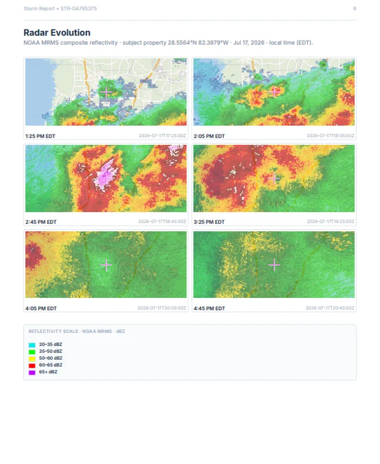
These are actual SkyCanvass deliverables: a property-specific storm report and an on-device LiDAR measurement report. Radar evolution, measured hail swaths, roof geometry, per-facet pitch — every page cites its source and carries a SHA-256 + Ed25519 signature.

Storm report cover for 305 N Main St, Hopewell VA — documented severe weather events in the property vicinity, dated Jun 23 2026.
Storm report coverSTR-19DFBCBA
Storm report radar evolution page — four MRMS composite-reflectivity frames over a street basemap.
Radar evolutionMRMS
Measurement report cover for 115 Old Logging Road, Front Royal VA — 330 sq ft roof, 1567 sq ft wall.
Measurement report coverPMR-B0617
Measurement report front-elevation page — a 3D mesh rendered from the on-device LiDAR capture.
3D LiDAR captureLiDAR
50 + DC
states with storm, code & jurisdiction data loaded
~42k
ZIP codes — the full USPS deliverable universe
119M
parcels mapped nationwide
7 yr
every signed report retained & verifiable

Works with your stack

Connected to the tools restoration runs on.

QuickBooksXactimateNOAA · NWSMRMS MESHNEXRAD Level-IIUSGS 3DEPGoogle Maps

Pricing

Priced to pay for itself on the first supplement.

Three flat per-company tiers — no per-seat role fees, and field crews are free forever.

Annual billing — 2 months free vs paying monthly
Crew
$249/mo
billed monthly

For an owner-operator crew running lean — flat per company.

2 storm reports + 5 code packets / month
  • 3 office seats included, +$25/user flat
  • Field crews unlimited and free — QR capture, no logins
  • Full CRM, e-sign, photo storage, calculators
Start free
Regional
$799/mo
billed monthly

For multi-location operations that run everything on one bill.

15 storm reports + 15 measurement reports / month
  • Unlimited office seats
  • Multi-location canvassing territories
  • Dedicated onboarding + direct founder line
Start free

See full pricing & features →

Questions contractors ask first

The honest answers.

Does this replace JobNimbus or AccuLynx?

Yes. SkyCanvass runs the full job lifecycle — leads, jobs, canvassing, documents, financials, and invoicing — plus the storm-evidence and field-photo pipeline most CRMs bolt on later. Most teams consolidate two or three tools into it.

How do the stamped photos actually work?

Your crew scans the job's QR code in the field app and shoots. Each photo is stamped with the property address, GPS coordinates, and a timezone-accurate timestamp, then filed to that job's Photos automatically — even offline, syncing when signal returns.

Where does the storm data come from?

NOAA and NWS radar, binned to MESH hail sizes in measured inches and tied to each affected parcel. It is evidence, not a probability score — every figure cites its source tile, date, and time. Each export is SHA-256 hashed and Ed25519 signed.

Can my office keep using QuickBooks?

Yes. Invoices, payments, and balances sync to QuickBooks Online so your books and your jobs stay reconciled without double entry. Xactimate connects too.

How long does onboarding take?

Most crews are canvassing their first storm within a week. We migrate your active jobs, set up your forms and roles, and train the field team — no pause in production.

Do I need a credit card to start?

No. An account is free, property lookup and the hail map cost nothing, and every account's first storm report is on us.

Put your next storm on the record.

See how SkyCanvass turns a verified storm into a documented job, a source-backed supplement, and a collected invoice — all on one property record. Start free; your first storm report is on us.